|
| 번호 |
제 목 |
글쓴이 |
등록일 |
파일 |
조회 |
|
| 65 |
세계의 화산활동 [火山活動, volcanic activity] |
서비 |
2014-09-27 | |
697 |
|
Thousands of people today started to evacuate the area near the Mayon Volcano in the Philippines after scientists warned of an imminent eruption. Compiled here are images from volcanic activity around the globe in the last couple of months. -- Lloyd Young ( 18 photos total)  Lava cascades flow down the slope of restive Mayon Volcano as seen from Legazpi City, Albay province, Philippines, on Sept. 17. Tens of thousands of people living near the Philippines' most active volcano began to evacuate after increased activity prompted government scientists to warn of an imminent eruption. Dozens of military trucks were dispatched to pick up the residents in the danger zones around Mayon Volcano in Albay province. An estimated 12,000 families or nearly 60,000 residents are in the danger zones that affect three cities and five towns in Albay province. (Zalrian Z. Sayat/EPA)  A Filipino soldier holds a child upon arrival in a public school turned into a temporary evacuation in Guinobatan town, Albay province, Philippines, on Sept. 17. Tens of thousands of people living near the Philippines most active volcano began to evacuate after increased activity prompted government scientists to warn of an imminent eruption. Dozens of military trucks were dispatched to pick up the residents in the danger zones around Mayon Volcano in Albay province. (Dennis M. Sabangan/EPA) # A farmer walks with his buffalo with the Mayon Volcano in the background in Albay province, Bicol region, south of Manila on Sept. 17. The Philippines has evacuated more than 12,000 people from around the foot of its most active volcano as the crater glows red and authorities warn of a possible eruption. Mount Mayon, known for its near-perfect cone shape in the coconut-growing central Bicol region, has recorded a series of recent quakes and rockfalls, indicating a possible eruption within weeks. (Reuters) # Lava from the Stromboli volcano flows into the sea, on Aug. 9. Stromboli, one of Europe's most active volcano, is part of the seven-island Eolian Archipelago just off Sicily in southern Italy. (Giovanni Isolino/AFP/Getty Images) # A Sept. 15 photo provided by the US Geological Survey shows geologists from the Hawaiian Volcano Observatory surveying the lava flow from the June 27th flow from the Kilauea volcano in Pahoa, Hawaii. On Sept. 16 Hawaii County spokesman Kevin Dayton said the slow-moving lava is expected to bypass homes in the Kaohe Homesteads subdivision, and the lava is about 19 days from reaching Pahoa Village Road. (US Geological Survey via Associated Press) # An aerial picture taken on Sept. 14 shows a plane flying over the Bardarbunga volcano spewing lava and smoke in southeast Iceland. The Bardarbunga volcano system has been rocked by hundreds of tremors daily since mid-August, prompting fears the volcano could explode. Bardarbunga, at 2,000 meters (6,500 feet), is Iceland's second-highest peak and is located under Europe's largest glacier, Vatnajoekull. (Bernard Meric/AFP/Getty Images) # The Tungurahua volcano from Banos locality, Andinean center of Ecuador, on Aug. 31. The volcano remains in 'high activity' according to authorities and more than a hundred volunteers have arrived to the site, coordinated by authorities, due the increase of the activity of the volcano. (JosÈ J·come/EPA) # Fluid lava streams from the June 27 lava flow from the Kilauea volcano in Pahoa, Hawaii. The June 27 lava flow is named for the date it began erupting from a new vent. The Hawaiian Volcano Observatory issued a warning on Sept. 4 to a rural community in the path of a lava flow on Hawaii's Big Island, as the molten rock moved to within a mile of homes. Observatory scientists said lava from the Kilauea volcano could reach the Kaohe Homesteads in five to seven days if it continues advancing through cracks in the earth. (Tim Orr/US Geological Survey via Associated Press) # The Bardarbunga volcano spewing lava and smoke on Sept. 14 in southeast Iceland. The Bardarbunga volcano system has been rocked by hundreds of tremors daily since mid-August, prompting fears the volcano could explode. Bardarbunga, at 2,000 meters (6,500 feet), is Iceland's second-highest peak and is located under Europe's largest glacier, Vatnajoekull. (Bernard Meric/AFP/Getty Images) # A panoramic view of the Tungurahua volcano in the Cordillera Oriental of Ecuador seen from Huambalo village, Ecuador, on August 4. Activity continued to increase at the volcano as new magma continues to arrive at its summit. Since the first ash emission a week ago, more and stronger explosions, as well as phases of continuous ash and gas emissions and milder strombolian activity have occurred, authorities report. (Jose Jacome/EPA) #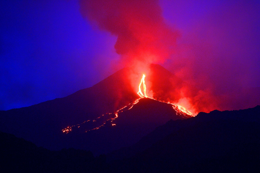 Lava flows from the Mount Etna volcano on the southern Italian island of Sicily near Catania on Aug. 13. Mount Etna is one of the most active volcanoes in the world and is in an almost constant state of activity. (Tiziana Fabi/AFP/Getty Images) #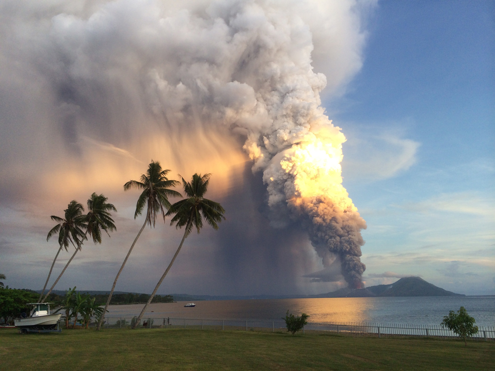 Mount Tavurvur erupts on Aug. 29 in eastern Papua New Guinea, spewing rocks and ash into the air, forcing the evacuation of local communities and international flights to be re-routed. Mount Tavurvur, which destroyed the town of Rabaul when it erupted simultaneously with nearby Mount Vulcan in 1994, rumbled to life early in the morning on the tip of the remote island of New Britain. (Oliver Bluett/AFP/Getty Images) # Lava flows from the Mount Etna volcano on the southern Italian island of Sicily near Catania on Aug. 14. Mount Etna is one of the most active volcanoes in the world and is in an almost constant state of activity. (Tiziana Fabi/AFP/Getty Images) #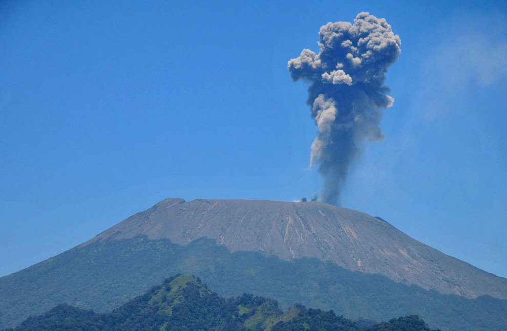 Mount Slamet spews volcanic materials viewed from Tegal, Central Java, Indonesia, on Sept. 11. According to media reports, Mount Slamet volcanic activity continues to increase. Residents were advised to stay away at least four kilometers from the 3,436 meters high volcano. (EPA) # Mount Slamet spews hot lava and volcanic ash as seen from Kaligua, Brebes, Central Java, Indonesia, on Sept. 12. The volcano sprayed volcanic ash and emitted fireballs from its crater to 1.5 kilometers height. (Gugus Mandiri/EPA) #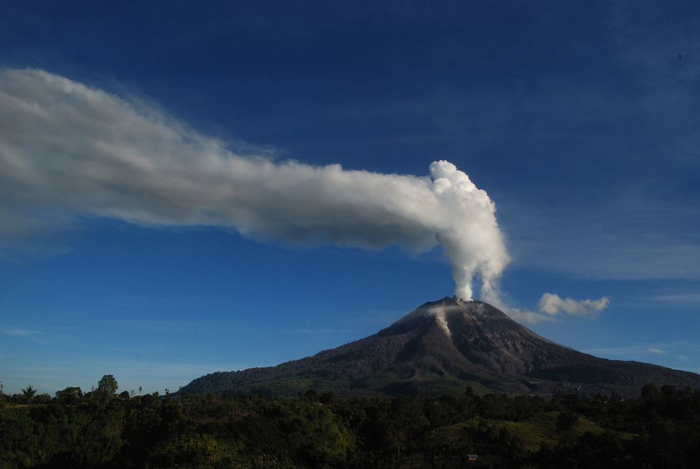 Mount Sinabung volcano seen as smoke and ash fill the air, in the Karo district of Sumatra island on Aug. 14. Tens of thousands fled their villages during a series of violent eruptions last year, and many have not been able to return home yet as the volcano continues to rumble. (Sutanta Aditya/AFP/Getty Images) # A picture made available on Sept. 13, 2014 shows an abandoned classroom at a damaged school hit by volcanic materials from mount Sinabung at Sigarang Garang village, Karo, North Sumatra, Indonesia, on Sept. 11, a year after the big eruptions. Sinabung volcano latest round of eruptions began on Sept., 15, 2013, killing 16 people and forcing more than 31,000 people to flee their villages. According media reports, a year after the eruptions of the 2,460-meter volcano, more then 7000 villagers still living at refugee shelter in government buildings. Indonesia has about 500 volcanoes, 128 of them classified as active and 65 listed as dangerous. (Dedi/Sahputra/EPA)S # Lava flows out of the Bardarbunga volcano on Sept. 14 in southeast Iceland. The Bardarbunga volcano system has been rocked by hundreds of tremors daily since mid-August, prompting fears the volcano could explode. Bardarbunga, at 2,000 meters (6,500 feet), is Iceland's second-highest peak and is located under Europe's largest glacier, Vatnajoekull. (Bernard Meric/AFP/Getty Images) #
|
|
|
|

 가입대상 : 동기모임
 개설일자 : 2004-10-12
 가입회원 : 185 명
 운영자 : 전기봉, 조영섭(섭이)

